Select a region


83cm might not seem a great distance – a healthy pace, the width of a desk or the height of a table - but when it relates to a rise in global sea levels, its enormity is almost beyond comprehension.
But that is what the UK National Oceanography Centre predicts the level of the ocean will rise by in 99 years’ time. If it does, islands will disappear, huge tracts of land will be submerged and millions of people will be displaced.
It is also the sobering statistic that underpins the Government’s planning for flooding, which it expects to happen with increasing regularity unless we start acting now.
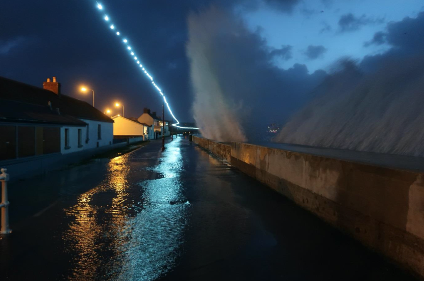
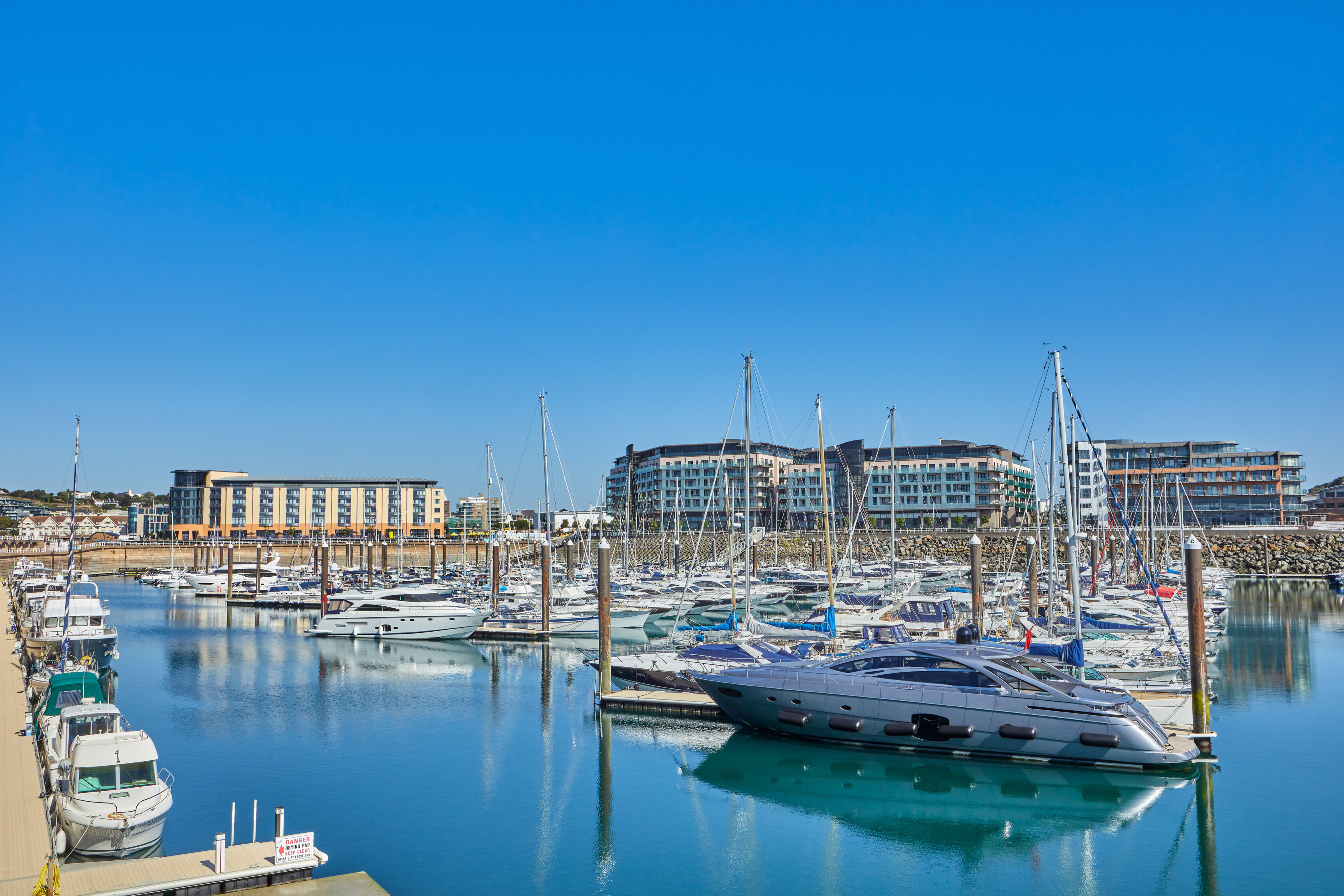
Pictured: The sea wall has recently been upgraded along a vulnerable stretch of coast, between the Gunsite and Bel Royal. (SoJ)
The draft Island Plan, which is in its consultation phase and will cover 2023-2025, might be an abridged version because of covid but, when it comes to flooding, its plans stretch beyond most of our lifetimes: until 2120.
Its long-term policy in this regard is clear: any development close to the coastline or a watercourse will only be supported when it has been proven to be appropriate and necessary, and it doesn’t impede a flood or sea defence, or the path of a stream.
The Island Plan’s stance on flooding and what Jersey should about it is underpinned by a study completed last year by a consultancy called Aecom.

Pictured: Flooding could cause a potential economic hit of £110m between 2020 and 2030 if no mitigation is put in place.
The predictions of the ‘Shoreline Management Plan’ force us to take notice: it identifies that 460 properties in the island are currently at risk of coastal flooding.
This will increase to 2,822 by 2120 as a result of climate change, with the potential economic hit of up to £110m between 2020 and 2030, with present levels of coastal and flood risk management.
The Shoreline Management Plan’s aim is to provide “a proactive and climate resilient management plan for coastal activity in Jersey” to “reduce risks to the community, environment and economy over 100 years”.
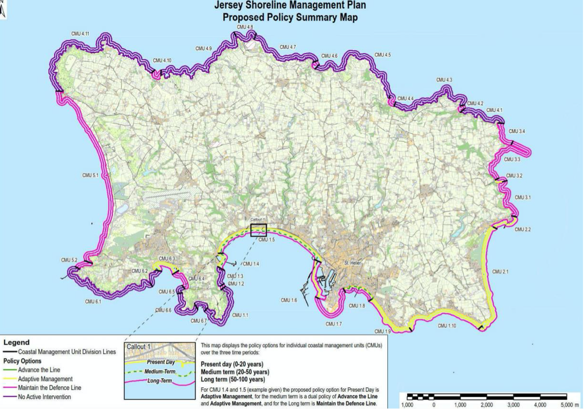
To cover such a long period of time, the SMP splits the century into three “management epochs” to help with planning.
With it obvious that different parts of the Island have different flood risks, the plan’s authors also split the coastline into 36 chunks and carried out individual risk assessments on each one.
It also identified four policy responses that it could apply to each area over the three epochs:
No Active Intervention: the shoreline will be left to naturally evolve without intervention. This generally applies to natural areas of the coastline which are currently undefended.
Maintain the Defence Line: existing coastal defences are maintained. The level of flood protection may decrease in some locations over time due to climate change resulting in sea level rise. This generally applies where the existing defences currently provide a reasonable standard of flood protection or prevent erosion of the shoreline.
Adaptive Management: proactive management and mitigation of coastal flood or erosion risk. This could include improving the standard of flood protection for an existing sea defence, constructing new defences, raising awareness of flood risk to local communities or recommending flood protection for individual properties.
Advance the Line: new sea defences are built seaward of existing defences. This approach will only be implemented in areas where there is currently a significant risk of coastal flooding or erosion, or where it will deliver additional benefits for the community, environment and economy, such as creating a new amenity space or other development opportunity.
As well as rising sea levels – which clearly will have more impact in low-lying areas predominately on the central-south and south-east of the Island – the consultants also looked at erosion, which impacts the rest of the coastline too.
By looking at aerial photos taken between 2003 and 2017, the report’s authors observed an annual average erosion rate of 30 cm at Portelet.
This was used to project a future erosion ‘buffer zone’ around the coastline, but only for areas of soft geology where there are no coastal defences.
Practically, this leads to the report recommending that no development should be allowed within 30m of the coastline in these high-erosion zones over the next century. It includes areas around St Catherine and the north coast.
Even those with only short memories and a cursory knowledge of the topography of Jersey will be able to appreciate where the main effort is required: past flooding around Beaumont, the sea wall being smashed to bits along the front, the mighty spring tides at the Harbour, the need for the Cavern and the flat aspect of the south-west coast all indicate areas of concern.
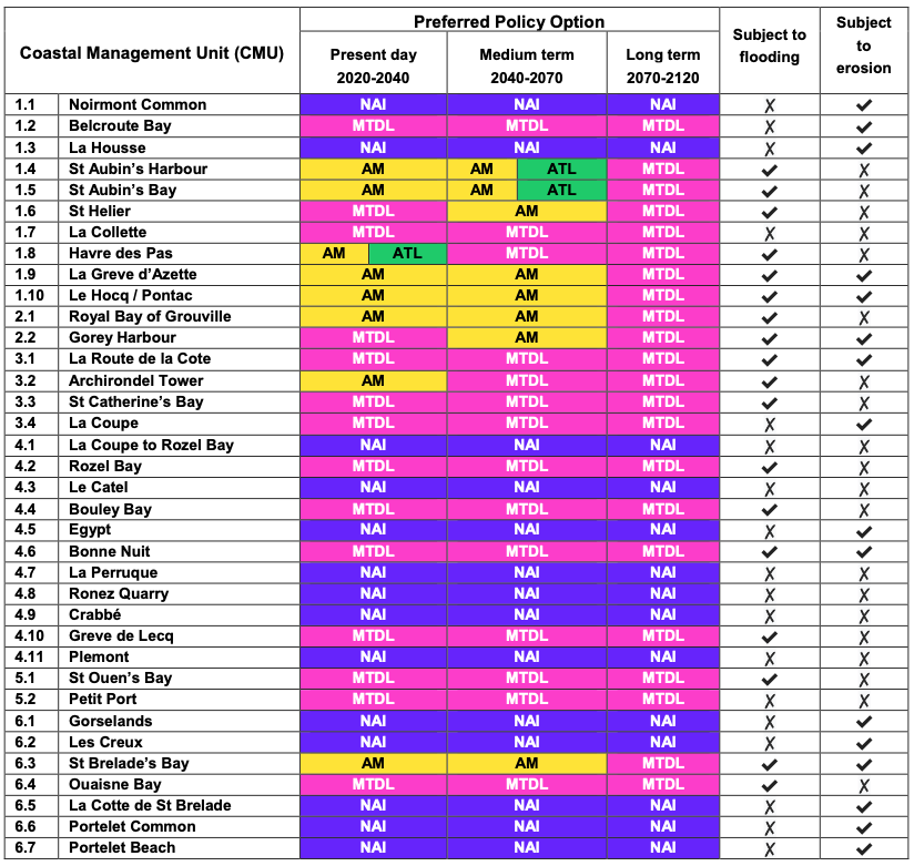
But now these observations and recollections have scientific backing and a plan to protect the Island from being swamped by rising sea levels. When it comes to where the most intrusive and expensive ‘Advance the Line’ option should be employed, the report says that new defences should be built at St. Aubin’s Harbour and St. Aubin’s Bay in the medium term (2040-2070) but - more urgently - they need to be built at Havre des Pas in the next 20 years.
Havre des Pas is an area of particular concern. Currently 39 properties in the area are at constant risk of flooding and this will rise to 694 by 2120. By then, it is estimated that 1080 properties currently built will be at risk of serious flooding of the type that happens once every 200 years.
When this serious flooding happens - a combination of an extreme spring tide and strong storms from the south-west - houses all the way to Bagot Road are at risk.
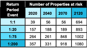
Pictured: The number of properties at risk at Havre des Pas.
The preferred option for the area is a dual policy of Adaptive Management and Advance the Line between now and 2040. The SMP says this will involve improving the defences to a 1:200 year standard of protection in the present day, and advancing the defence line into the sea "in some localised areas".
Where the defences are precisely built, however, is not specified, as they would be "based on the findings of appropriate engineering and environmental assessments and be subject to public consultation".
In other areas of concern, including St. Aubin's Bay, a new sea wall could be built further out into the bay. Here, land reclamation is mooted:
"The dual policy - of Adaptive Management and Advancing the Line in the second epoch - ensures that the entirety of St. Aubin’s Bay is protected from the impacts of flooding, and provides an opportunity for moving the defence line forward where it is both appropriate for the community, and serves a purpose," concludes the SMP. "This purpose could be providing better protection where the flood risk is greater, and more land for business development and economic growth."
Until 2040, Adaptive Management is recommended, including greater community awareness and upgrading existing defences, similar to what has recently happened between the Gunsite and Bel Royal.
Around St.Helier, the SMP recommends Maintaining the Defence Line until 2040, followed by Adaptive Management between 2040 and 2070, before returning to Adaptive Management in the third epoch. This includes building new defences in 20 years' time, although the report adds that this approach does not currently include for any works that the Ports of Jersey may undertake before 2040.
Pictured: The plan suggests that Ports of Jersey should have responsibility for its own flood prevention defences.
The SMP points out that, in the absence of any joined-up plan between Ports of Jersey and its owner, the Government, the latter's defence line should be immediately behind the Harbour.
"While this setback alignment would leave residual flood risk in front, this should be managed by Ports of Jersey and will not be funded by the Government of Jersey. The only residual flood risk in the present day will impact the area managed by Ports of Jersey," it says.
In other vulnerable areas around the Island, including St. Brelade's Bay, Grève d'anette, Le Hocq, Pontac, the Royal Bay of Grouville and Gorey, the plan proposes improving existing defences over the epochs.
The estimated cost of delivering the SMP is £198m over the next 99 years. The majority of the money is proposed to be spent in the second and third epochs - approximately £84.5m and £77m, respectively - resulting in approximately £36.5m forecast to be spent in the first epoch.
The SMP suggests a number of next steps, which include a detailed plan on how to implement its recommendations for between now and 2040, and the creation of a coastal monitoring programme within two years, which should include an ‘extreme weather database’ to record meteorological and sea conditions before, during and after storms.


Comments
Comments on this story express the views of the commentator only, not Bailiwick Publishing. We are unable to guarantee the accuracy of any of those comments.