Select a region


A huge overhaul of St. Helier's roads is coming if the island wants to hit its carbon targets... Express delves into a £130,000 report setting out how to end "car dominance" in Jersey's most populous parish by 2024.
Created by consultants Arup, the 'Stage 3 Report for its St. Helier Public Realm and Movement Strategy' touches on lower speed limits, new cycle routes, trees, creating more retail buzz, closing roads more often for public events and - you guessed it - tweaks to Broad Street as it sets out a strategy to make transport more eco-friendly around town.
Based on comments from 25 stakeholders and 18 responses to a survey, the plan breaks down its roads vision into four key pillars: bridging the ring road, creating an "active travel network", growing a "vibrant core" in town, and creating a number of liveable neighbourhoods.
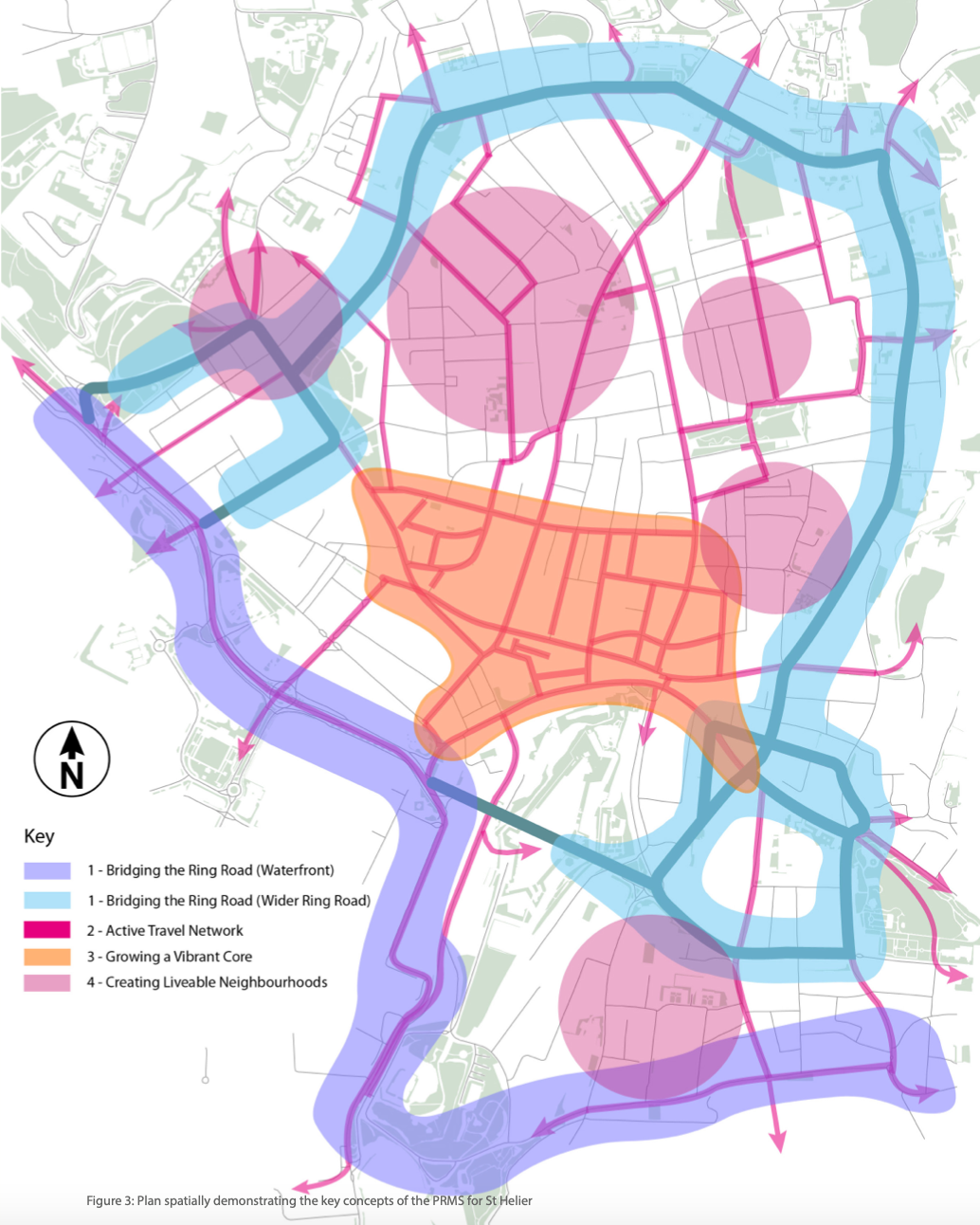
CLICK TO ENLARGE: An overview of the plans the report lays out.
Express examined each idea in further detail...
Arup's report describes the current set-up as causing “significant severance between the town and outlying communities and offers unpleasant conditions for people walking and cycling.”
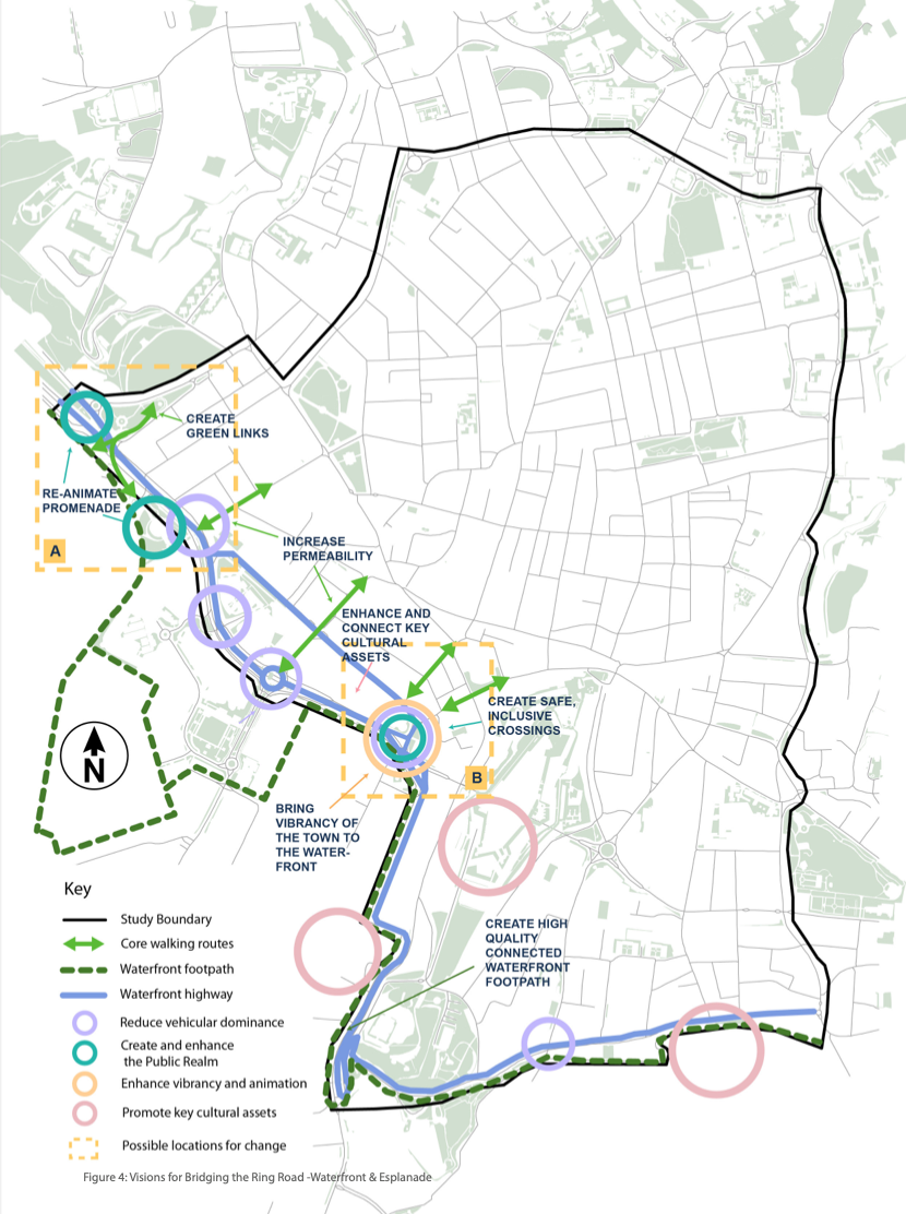
CLICK TO ENLARGE: Proposals to 'bridge' the Ring Road across the Waterfront and Esplanade.
Though this report preceded the release of the Jersey Development Company's latest plans for the Waterfront, its general ideas align with many of its principles, such as increased connectivity in town.
A key idea is reducing the dominance of vehicles by reducing the space given to them at the junctions of La Route de la Liberation/La Route du Port Elizabeth/Castle Street and Route de la Liberation/Esplanade/Gloucester Street.
It also suggests:
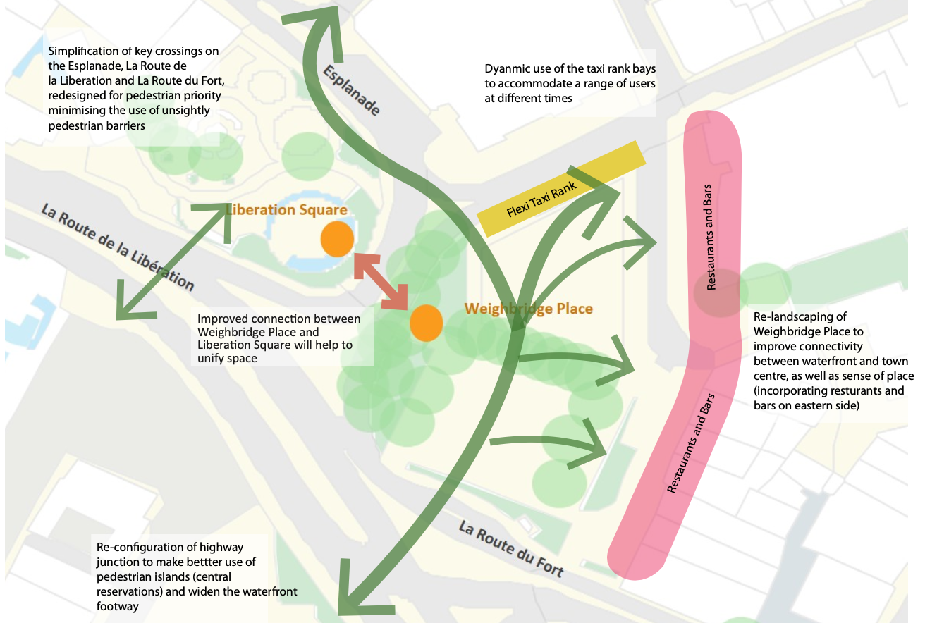
CLICK TO ENLARGE: Ideas to further connect Weighbridge Place and Liberation Square.
This is reflected in the more recent plans for the overhaul of the Waterfront published last month, with the Jersey Development Company outlining similar ideas to this, including:
However, they appeared hesitant about a radical overhaul of the Esplanade, saying that “without a shift towards sustainable transport modes and significant reduction in the island's traffic volumes (>30%), the current provision of six lanes and underpass would need to be retained.”
In terms of the wider scope of the ring road, the report outlines a “shift in priority” to those participating in active travel whilst still allowing for “moderate levels of vehicular access.”
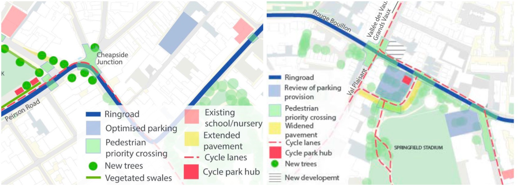 CLICK TO ENLARGE: The Cheapside and Val Plaisant Junction plans.
Noting the number of schools in the ring road area, it adds that “many children must either walk, cycle or use public transport to get to school,” and others must walk from the bus station.
In addressing what it calls the current “severance” created by the ring road, it suggests:
The plan sees key junctions are reimagined to prioritise cyclists, walkers and other modes of active travel.
It also suggests more greenery, which it states will additionally serve “more practical purposes for urban drainage, air quality, and shade.”
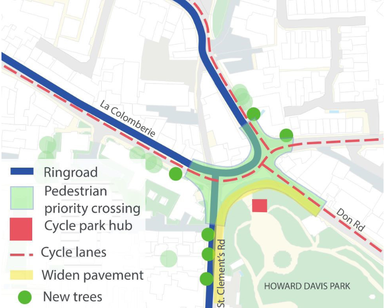
CLICK TO ENLARGE: The Colomberie junction plans.
Improvements to three junctions in particular are highlighted in the report, namely:
Peirson Road/Cheapside Junction
Trinity Road/Rouge Bouillon/Val Plaisant Junction
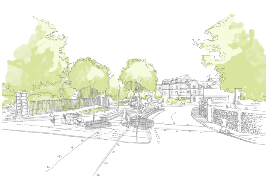
Pictured: A sketch of what the La Colomberie/St Clement’s Road/Don Road Junction could look like.
La Colomberie/St. Clement’s Road/Don Road Junction
Similar to its suggestions to overhaul junctions and ring road areas, the proposal also presents “key routes that will prioritise movement by walking and cycling as part of an Active Travel Network.”
Ideas touted as part of this also include reallocating space on busier streets through means such as: extending and resurfacing footways, making crossings safer, removing of on-street car parking, adding more cycle parking and cycle routes, and street furniture on underused areas of footway.
Some space would also be repurposed for the community to use, and trees and plants would be added.
The plans for the town centre revolve around reducing car dominance and helping retail thrive.
Here, the plans again involve making pedestrians the priority, while cyclists will also be able to benefit from a small number of key routes through the area.
On-street parking would be relocated or removed, to make space for “new creative uses and retail activities,” and traffic could potentially be restricted at different times of the day to minimise car dominance.
The report later states that “flexible spaces, including through temporary, periodic street closures” would help to create more events to draw in visitors to St Helier too.
Pointing to more pedestrianisation too, the report says that “pedestrian interventions (both hard and soft infrastructure) will be a priority within the Vibrant Core, as exemplified by King Street which already benefit the area.”
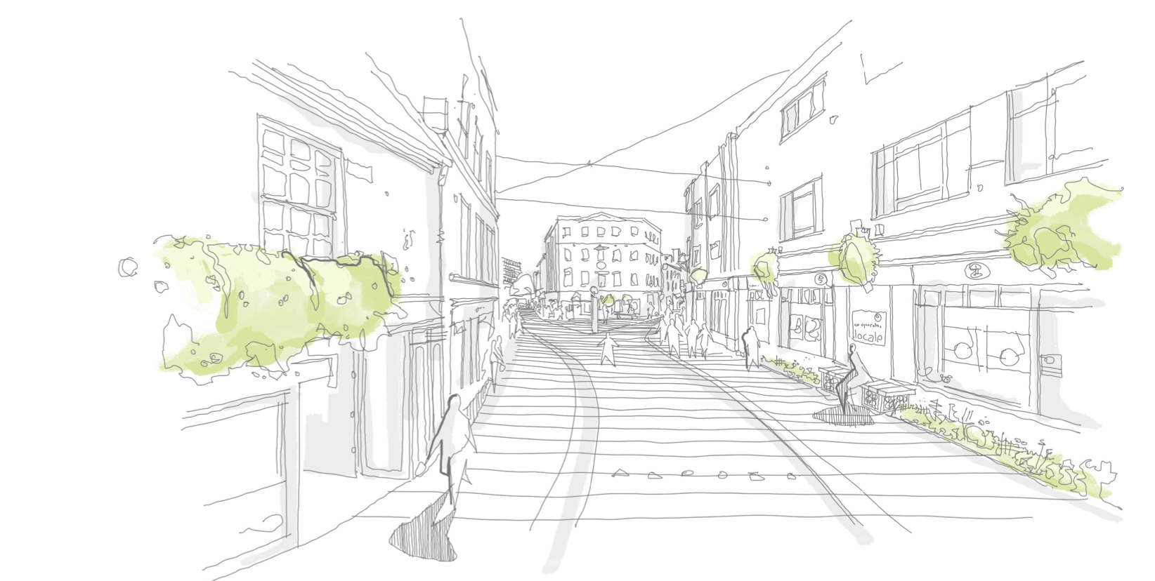
Pictured: Indicative plans included in the report for Broad Street and Charring Cross.
The subject of pedestrianisation recently became a hot topic for islanders earlier this year, following a heated debate on the continued closure of Broad Street, and the States Assembly’s eventual decision to keep it closed to most road traffic until the end of the year.
The report uses Broad Street as a potential illustration of developments, and includes it in a list of potential projects it says are “primed for development and delivery", listing ‘Phase 1’ of a £500,000 development as being earmarked for construction in 2022, subject to funding and resources.
The plans aren't simply focused around helping retail to thrive and improving access - they're also about making St. Helier's neighbourhoods more pleasant places to live.
Arup's report observes that “inclusive mobility is intrinsic to the quality of life, but St. Helier has developed into a place where the car dominates.”
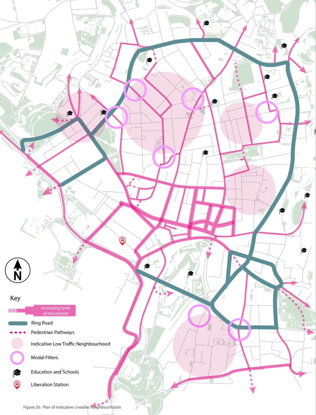
CLICK TO ENLARGE: An outline of where the 'modal filters' would be put around the parish.
A main driving force of this will be the installation of modal filters, which are blocks at a single point in a road that that allows walking, cycling and emergency vehicles to pass through, but stop other types of vehicles.
Reduced speed limits would also be introduced, and new community spaces called ‘pocket parks’ created temporarily from areas where parking has been removed or altered, but with a mind to have them as permanent fixtures.
Along with documents like the Sustainable Transport Policy and Island Plan, this report and its ideas will now be reviewed, with its principles used to guide investment in the 'Public Realm Works Programme', which will see ideas reflected in tangible projects.
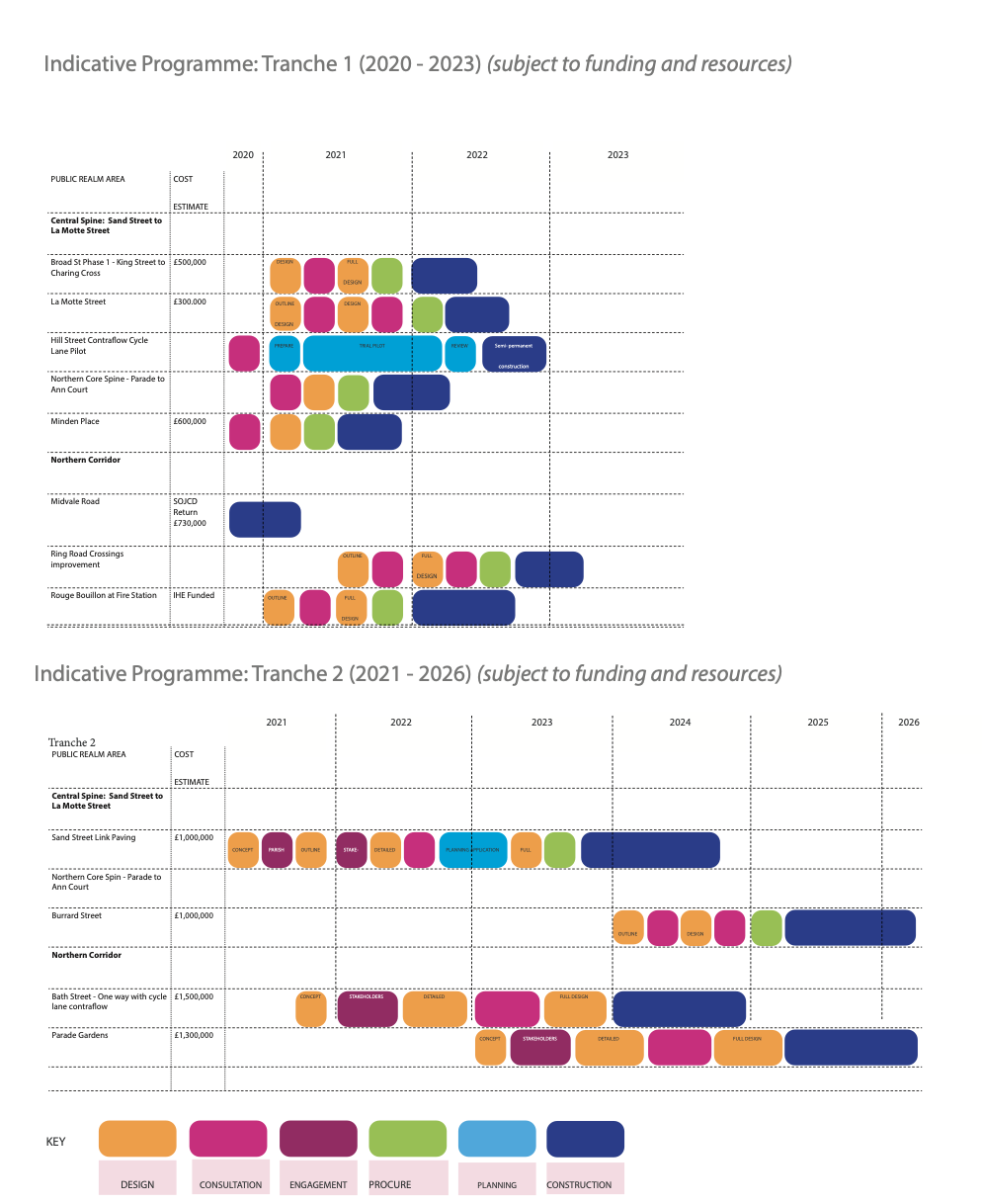
The Programme has circa. £4m of funding allocated to it, having had its initial £14m reduced due to covid - however, this figure might change. The Government will be looking for more funding through the planning system and charges for less eco-friendly transport.
Ideas already forming part of the programme, which will only go ahead if they get the funding needed, include a development of La Motte Street, a redevelopment of the Fire Station, and Ring Road crossing improvements.
While the proposed short-term Island Plan backs many of the report's proposals, it remains to be seen how they are fully implemented, and whether they will be welcomed.
Indeed, as the heated conversations around the potential closure of Broad Street demonstrated, the past year has taught us that changes at the heart of the island, tend to strike a chord in the hearts of islanders too.


Comments
Comments on this story express the views of the commentator only, not Bailiwick Publishing. We are unable to guarantee the accuracy of any of those comments.