With a week to go on the public consultation for proposed road changes around the Saltpans, St Sampson’s Douzaine is finding out what residents think about the plans.
Parishioners are invited to a meeting tomorrow night where the proposed new road infrastructure will be discussed.
The parish authorities have not commented publicly on the plans yet, but they’ve previously urged caution on new developments in the parish.
Just a month ago, the constables issued a statement in which they said the Douzaine was still trying to push back against development plans for the parish – saying that “concerns continually highlighted” have “largely been ignored”.

Now, the parish has invited residents to attend tomorrow night’s meeting “on the proposed new road infrastructure in the Saltpans that is the subject of a recent Outline Planning Application to the Development and Planning Authority”.
The application is referenced OP/2025/1028 – Saltpans Vinery and it has a deadline of Tuesday 22 July for any planning responses.
The plans – which can be viewed HERE – concern the proposed redevelopment of the Saltpans Vinery site which stretches between the Saltpans, Braye Road, and Route Militaire.
It is adjacent to the Kenilworth Vinery site – now renamed Parc Le Lacheur – which was bought by the States to be redeveloped for housing by the Guernsey Housing Association. That section of vinery site stretches between the Saltpans, Lowlands Road, and Braye Road.
To enable these developments to happen, a new road network is proposed which will affect people already living in the surrounding areas, as well as those who work there, or have to use the existing roads for any reason.

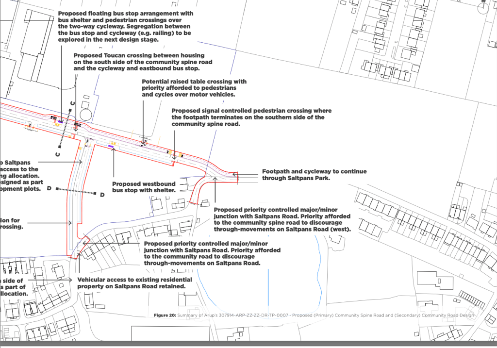
The proposed changes include turning on the traffic lights installed on Route Militaire at the entrance to what was going to be the Data Park, and creating a ‘spine road’ through the new development linking Route Militaire with the Saltpans from the Data Park traffic lights.
Shared pedestrian and cycle pathways, signal controlled pedestrian crossings, and Toucan crossings could be installed throughout the Saltpans vinery development along the new spine road.
On the existing roads, through traffic along the Saltpans will be “discouraged” along with other Ruette des Habitants proposed for the surrounding areas which would disallow any non-residents from driving along Robergerie Road, Rue des Monts (north of Mont Marin), Rue Des Pointues Rocques, and Duveaux Lane.
Other roads could be made one way, including Les Savaugees, as suggested in the Better Transport Plan for the north which was published last year.

The planning application for the Saltpans Vinery site is active now, with the public consultation closing on Tuesday 22 July.
The meeting organised by St Sampson’s Douzaine for parishioners to discuss the plans will be held at the Chambre de la Douzaine, Le Murier, St. Sampson at 19:00 on Wednesday 16 July.