Select a region


An experienced geologist has branded plans for a skatepark at South Hill as a “disaster”, warning that they would threaten historical, archaeological, and geological significance dating back 500,000 years.
Dr John Renouf, member of the Société Jersiaise's archeological division, is arguing that building the skatepark there would be a “lamentable” move which will irrevocably damage the integrity of the Mount Bingham landscape.
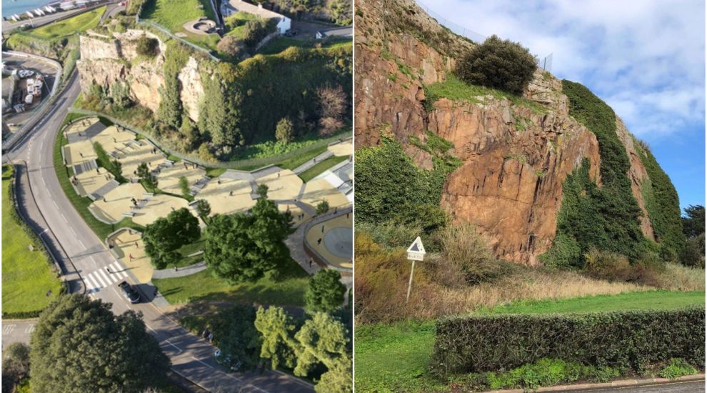
Proposals for a skatepark at South Hill, which is the Government’s preferred site, were released on Wednesday ahead of a States debate next week on whether it should be located there or at Les Quennevais.
Pictured: Within the quarried ravine, is also a dyke featuring a very "particular" type of rock, called minette.
One of the main reasons the area is of “inestimable geological importance”, Dr Renouf told Express, is that in the ravine between the hill’s highest point and west of the quarried wall, there are the rare remnants of a cobbled beach from over 500,000 years ago, which has risen up by 35/40m through the years due to the change in sea levels.
“This is a rare phenomenon to have such a well preserved beach,” Dr Renouf said of the landmark.
He described it as being “of great age and scientific importance at international level, not just Jersey level”, and one of the “best” examples of its kind along the Normano-Breton Gulf.
He even suggested that the cobbled beach, which is listed as a site of special interest by the Planning Department, could have at some point been a place that an early human ancestor, ‘Homo heidelbergensis’, had visited once the high tides had retreated, adding a new chapter to Jersey’s evolutionary history.
Video: A look around the South Hill site.
He pointed out that the cliff face itself also includes undisturbed rock outcrops, which “represent the rounded rocks of that high sea level”, giving another historical snapshot to several hundred thousand years ago and the way in which the Channel Islands' cliff faces formed.
From a more recent historical perspective, Dr Renouf noted that the ravine where the beach was first uncovered, from the JE substation down to the road over Mount Bingham, was quarried in the first place in the early 19th Century, as a means of producing a vertical cliff face that would prevent the French and other invaders from taking South Hill, as part of the overall fortification of Town Hill.
Ahead of next week’s debate, Dr Renouf offered a message to States Members: “If you as a representative of Jersey in the Government are content to destroy so valuable a site, which is important from a international scientific point of view, and also from a scenic point of view, then go ahead and do it - but don’t expect to be lauded or praised for it.”
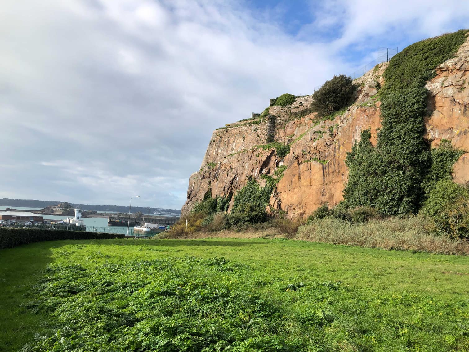
Picture: Dr Renouf said that the current designs for South Hill skatepark would go right in the middle of where the beach remnants are.
Though the skatepark’s feasibility study acknowledged that the site was within “the Area of Archeological Potential”, the cliff’s 500,000-year historic background was not mentioned.
The report did, however, highlight the “remains of a German prisoner of war camp and camp buildings that were located south of the Jersey Electricity Company Switching Station and east of their cables that run through the proposed site.”
To mitigate against any archaeological impact, the report suggested:
It added that a Heritage Impact Assessment would also be required to support any planning application made following the vote, in addition to an Archaelogical Desk-Based Assessment.
The study also implies there could be wider planning difficulties with the park, categorising its planning risks as "moderate."
It further states any work would need to mitigate a risk of rock fall, but claims that "this can be managed by the introduction of a rock fall barrier," without making the site financially unviable.
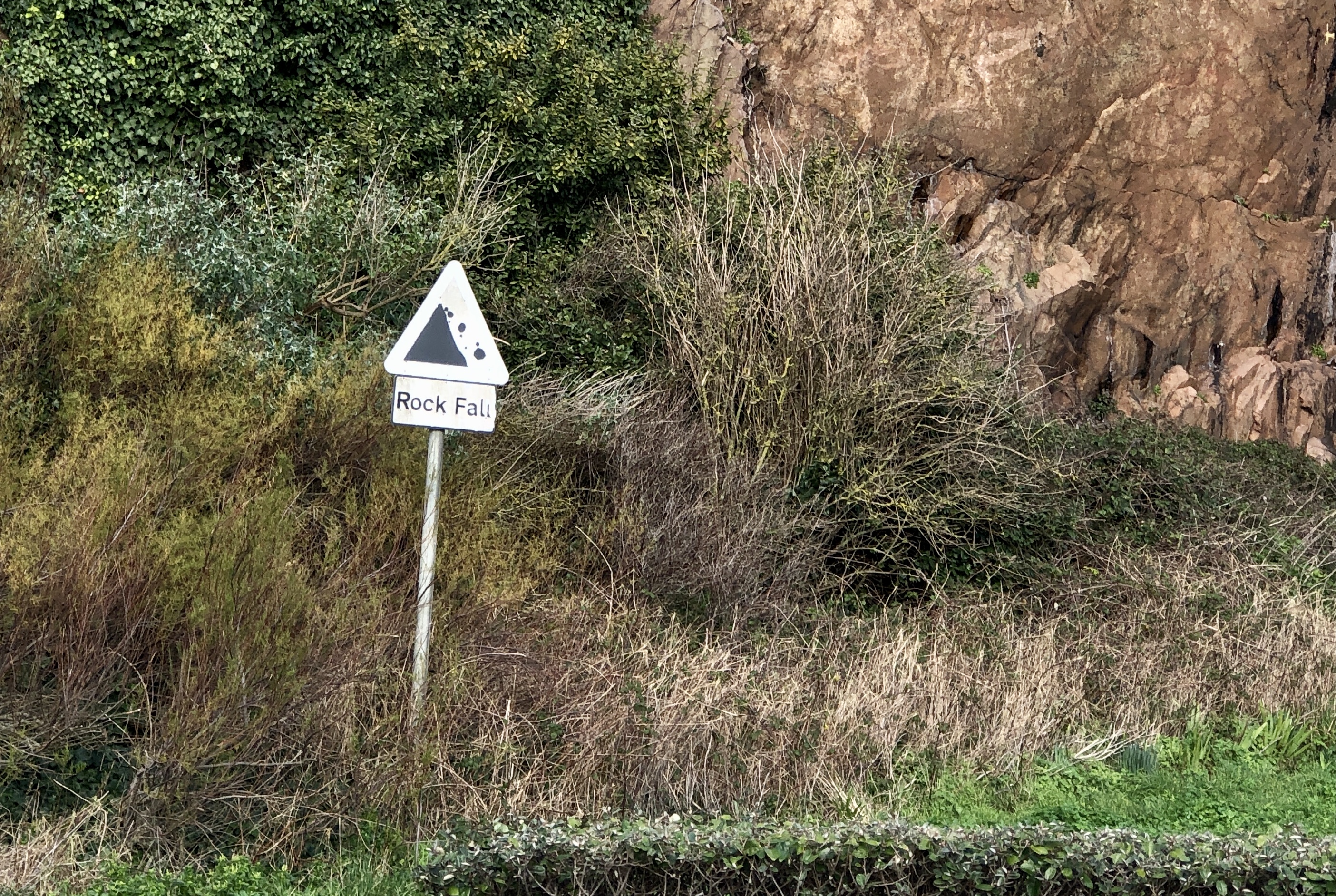
Pictured: A sign at the base of the cliff face warns of potential rockfall.
However, though the report acknowledges some of the risks, Dr Renouf argues that it doesn't go far enough, and that more should have been done to make the site’s history clear before the vote.
“They didn’t present any of the information I’ve presented - how can anyone make a decision without this information?" he asked.
He has now written to States Members to share his concerns in a letter you can read in full below.
When Express put his concerns to Government, a spokesperson replied: “Next week’s States Assembly debate will consider all aspects of the site options.
“If South Hill were the approved site (depending on next week’s States Assembly decision), it would have to go through a planning application, and there are criteria for such sites.”
"It is with alarm that I read of the proposal put forward to site a skate park on Mount Bingham/South Hill. If the preservation of Jersey's heritage means anything at all, this development must be resisted.
First of all the ravine from the JE substation down to the road over Mount Bingham is part and parcel of the history of Fort Regent. It was quarried out in the construction of the overall fortification of the Town Hill in the first decade of the nineteenth century.
These works were designed to prevent an enemy from taking South Hill and establishing armaments there, armaments that would command the approaches to Fort Regent up the Glacis Field.
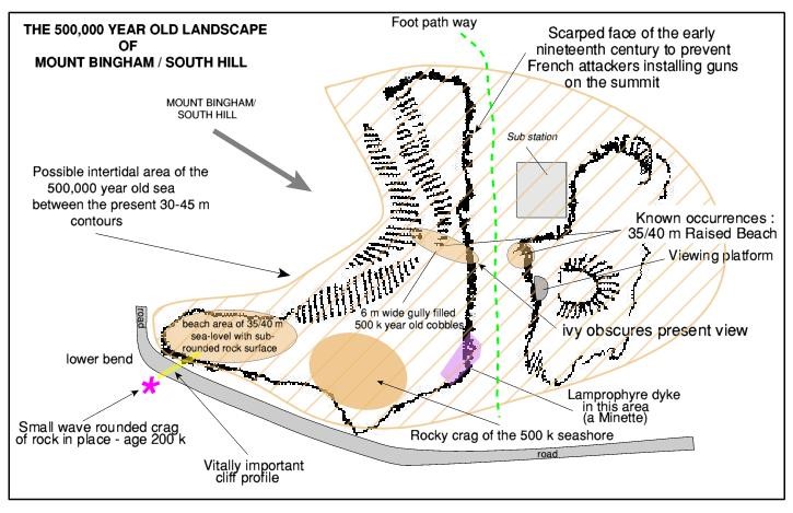
Secondly the whole of South Hill from east of the JE substation to the corner of the road descending to the harbour is a single landscape (geomorphological) entity of inestimable geological importance.
The quarrying works of the early nineteenth century cut through three different geological elements.
The principal one was Fort Regent Granite, though this by itself is of no great import. Secondly, a vertical, metre wide dyke of mica lamprophyre—known as minette—a particular and rather interesting rock type, was exposed in the extreme southwestern angle of the quarried wall.
Thirdly, and the most important discovery of all, there was revealed the preserved remnants of a raised cobble and sandy beach (at a JD height of 40 m) continuous, at the time of its formation, between the highest point of South Hill, to the west of the quarried wall, and the opposite wall to the east, above and to the south of the substation. This raised beach is an SSI registered with the Planning Department and has an estimated age of c. 500 thousand years.
Outside the quarried ravine, the cliff face from its southern end to the corner of the road below—where recent securing of the face with rock bolts and netting was done—is a cliff of great antiquity. In combination with a little known and even less appreciated wave rounded rock outcrop, just to the seaward side of the road corner below, it provides an integrated cliff profile unique in the Channel Islands and adjacent areas. This enables geologists to understand a very important aspect of the origins of the steep coastal cliffs of the Channel Islands and adjacent Cotentin, namely how old these cliffs are and how they developed over the past 500 thousand years.
All this may seem remote from the modern world but not so. Jersey Heritage is seeking to create an internationally known Geopark of Jersey. This relates in no small way to the significant efforts of the past decade to put the Jersey on the map as the Ice Age Island linked closely to its connections to our relatives of the past, the Neandertals. The very origin of La Cotte de St Brelade is to be put in context with the Mount Bingham cliff profile to add understanding of the origin of La Cotte itself.
But the likely 500 thousand year age of the cliffs at South Hill adds another and so far undescribed element of human evolution to Jersey's story : that of Homo heidelbergensis a slightly earlier Homo species than H. neanderthalensis.
When the sea retreated from the high of the South Hill raised beach, the subsequent landscape would have been a possible land that Homo heidelbergensis visited just as the Neandertals were to do several hundred thousand years later.
This landscape also has an historical dimension finely displayed in the Ouless painting related to the visit of Queen Victoria to Jersey in 1846.
The attempt to create a skate park entirely within this ancient Jersey , quiet landscape will destroy its integrity by altering the ground plan of the area through the erection of raised concrete bankings and by the creation of an alien modern artificial structure.
And this is not to mention the loss to St Helier of an important leisure environment, which is a natural area of scenic beauty and overall quiet, linking the town by foot to the land- and sea-scapes beyond."


Comments
Comments on this story express the views of the commentator only, not Bailiwick Publishing. We are unable to guarantee the accuracy of any of those comments.