Select a region


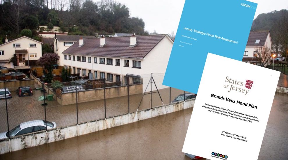

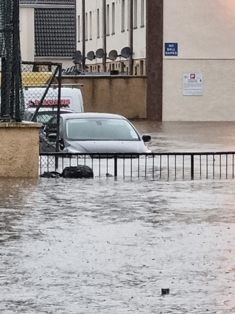
After major flooding devastated homes around Grands Vaux yesterday, Express examines why the area is so vulnerable, the plans in place for dealing with extreme flooding and when they were last updated.
Christie Bailey and Fiona Potigny report...
The vast majority of the Grands Vaux area is either assessed as medium or high-risk of inland flooding.
A 'Strategic Flood Risk Assessment' carried out for the Government by consultants AECOM in 2021 as the Bridging Island Plan was under development explains why this is: "The Grands Vaux Reservoir basin is small and can fill very rapidly during a storm. The flood volume, in severe weather, can be greater than the capacity of the basin and, in combination with the steep topography of the land around the reservoir, the reservoir frequently overflows, as it is designed to do."
It adds that the existing drainage network in St. Helier can only accommodate "low return period events" - known as "1 in 1 year" events - but "would be unable to handle events of greater magnitude."
What Jersey has experienced recently is closer to a “1 in 100 year” event.
AECOM define this as a period “with more than 53mm of rain within a six-hour duration”.
On Tuesday morning, Jersey Met reported: “We've recorded 35mm of rainfall at Maison St. Louis Observatory & 42mm at Howard Davis Farm to 10am this morning. Rainfall swirling around the Island will move south over the next few hours clearing around 4pm with some further heavy bursts possible.”
We've recorded 35mm of rainfall at Maison St. Louis Observatory & 42mm at Howard Davis Farm to 10am this morning. Rainfall swirling around the Island will move south over the next few hours clearing around 4pm with some further heavy bursts possible. pic.twitter.com/QIFyH3fmw2
— Jersey Met (@Jersey_Met) January 17, 2023
Grands Vaux residents have been affected by torrential downpours several times in recent years.
In November 2017, the area was hit alongside Beaumont in St. Peter and areas of St. Lawrence, while heavy rain in March 2020 saw water flood the roads and enter homes. The nearby pond had to be de-silted to increase capacity.
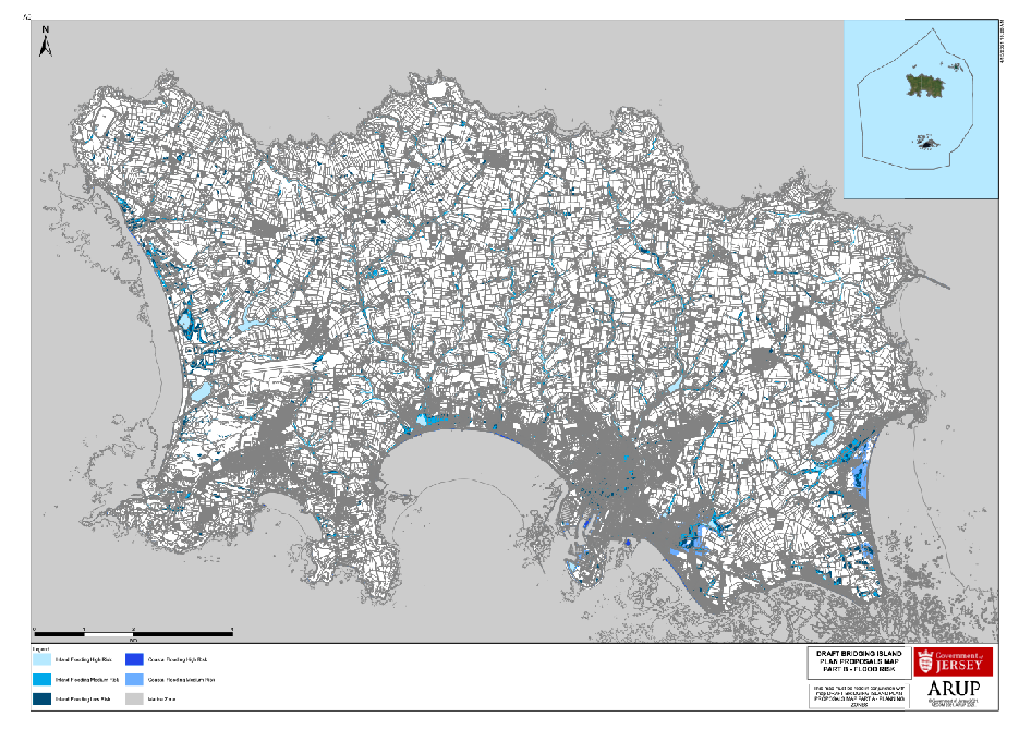
CLICK TO ZOOM: A map showing the areas of the island highlighted as being most at risk of flooding.
One of the strongest emergency responses came in February 2014 - even though the threat eventually passed.
A ‘Cobra-style’ meeting of emergency services was called to deal with the risk of flooding as high tides, saturated ground conditions and heavy rainfall expected to be a “one in 120 year event” threatened to combine to create a potential disaster.
Members of the public were warned in advance to take steps to protect their properties, and officials confirmed to Express at the time that the situation was so severe that they had considered evacuating people from their homes.
The Red Cross was also put on “stand-by”.
However, the risk fortunately diminished throughout the day, with the worst of the weather hitting Guernsey.
While flood plans had been in place previously, 2018 saw the launch of a large-scale exercise called ‘Operation Fluvius’ to stress-test them for a major tragedy.
All authorities were involved in the exercise, which identified a number of areas for improvement - among them, to make an updated flood plan for Grands Vaux publicly available, and work to raise awareness of the risks of flooding in the area.
A leaflet was produced on flood risks and information published online - including a newly updated Grands Vaux Flood Plan.
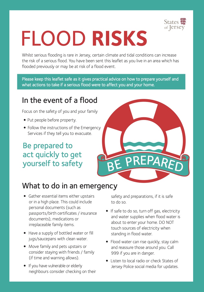
Pictured: A page pf the leaflet created about flood risks explaining what to do in an emergency.
The plan states on its cover that it was to be reviewed in March 2021 - however, it is unclear whether such a review ever took place. Express asked the Government and had not received a response at the time of publication.
Deputy Sam Mézec posed that same question to the Chief Minister in the States Assembly this morning.
Deputy Kristina Moore pointed out that she had not been in government in 2021, adding that Ministers would be looking at the capacity of the island's underground infrastructure.
The Grands Vaux Flood Plan
Speaking at a press conference yesterday, Chief Fire Officer Paul Brown said that the island's emergency services and other key authorities were following their pre-established flood plan.
The current publicly available version of the Grands Vaux Flood Plan, which was last updated in 2018, outlines the multi-agency response and co-ordination arrangements for a flooding event in the area.
The document is intended for organisations that would participate and support the response and recovery of the Grands Vaux community being affected by flooding.
It explains that a Strategic Coordination Group (SCG), made up of senior members of the emergency services and relevant Government departments, will be set up to be responsible for determining the combined, strategic response, formulating policies and setting objectives.

Pictured: Chief Fire Officer Paul Brown (centre) explained at yesterday's press conference that authorities were following their pre-established flood plan.
A Tactical Co-ordination Group (TCG) will also be established to be set implement the policies and strategic decisions made by the SCG, develop the tactical plan and co-ordinate activities and assets.
The key objectives of the plan include defining what factors would trigger the plan, describing the roles and responsibilities of different responding agencies, and outlining considerations for the communication of essential public information.
The plan predicts that there is likely to be warning prior to severe weather, however accepts that there may little or no warning prior to a flooding incident with the emergency services being notified by members of the public in affected areas.
Plans are outlined for a Major Flood Event, which is described as "a predicted forecast flood event for Grands Vaux and the surrounding area where there will be a continuous moderate or heavy rainfall which presents a risk to life and properties".
Key public health risks discussed in the plan include fast or deep water, flood water contamination, fallen power lines and trees, exposure to electrical hazards, and the possibility of carbon monoxide poisoning if petrol or diesel generators are used indoors to assist in pumping out flood water.
The plan divides the Grands Vaux area into two sections in order to assist in managing a phased evacuation. Sector 1 comprises of all properties within the area starting from Grands Vaux School and running along Les Grands Vaux until Troy Court, whilst Sector 2 contains all properties that are located in and around the area starting at the bottom of Langley Park and finishing at the junction of Trinity Hill.
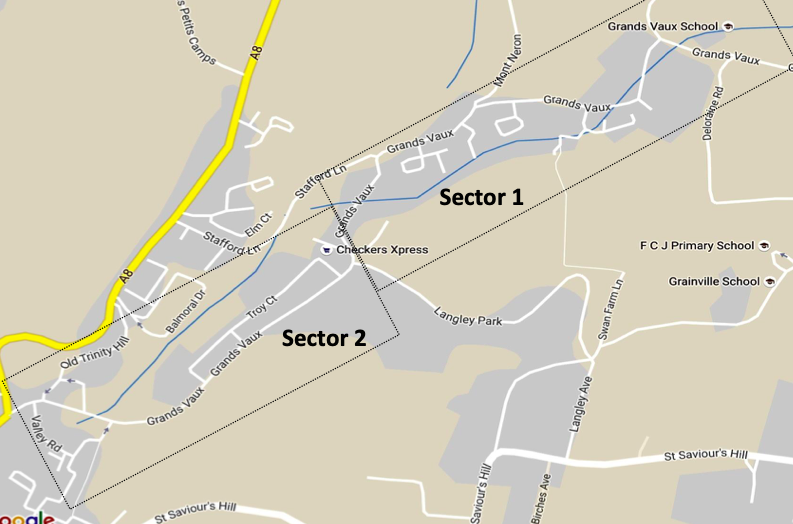
Pictured: Sector 1 and Sector 2 as outlined in the plan. (Government of Jersey)
The plan also considers the potential wider impacted effects to the rest of St. Helier which would be known as Sector 3 if required.
The plan proposes that early consideration should be given to setting up an Evacuation Coordination Group to help plan the evacuation, however accepts that an evacuation resulting from a flash flood that gives little or no warning, forces immediate action, and gives limited preparation time.
The TCG would be responsible for searching and evacuating all Sector 1 properties, which may involve deploying the Search and Rescue Coordination Group (SARCG).
During this time, additional emergency responders and partner agencies will inform and warn occupiers in Sector 2 of the possible need to evacuate should the conditions continue to deteriorate in Sector 1.
The plan describes large scale evacuation as "the last resort" which should be "only undertaken when absolutely necessary". It is suggested that it may be safer to advise people to seek refuge in the upper storeys of a building rather than run the risk of being overcome by flood waters.
Pictured: The water level yesterday morning at Pillar Gardens, which is included in the Sector 1 area outlined in the plan. (Steven Ozouf)
The decision to evacuate the community will consider the nature and extent of the flood, the anticipated speed of onset, the number and category of people needing to be evacuated, evacuation priorities, and availability of resources.
The plan explains that is is difficult to pre-determine safe evacuation routes in a flooding incident as it will depend on a number of time-specific factors, but maps out possible evacuation routes.
It is suggested that evacuees will travel on foot or in their own vehicles to a pre-determined place of safety, but the plan suggests that buses and coaches could also be arranged if required.
There is also the consideration that some people may be stranded and in need of rescue using boats, helicopters or high-clearance vehicles.
The Grands Vaux Flood Plan also proposes a list of possible locations to be used as evacuation assembly points, including nearby schools, community centres, and Parish halls.
The importance of establishing effective communication arrangements to convey warning messages to the public is also outlined in the plan. Suggested ways of communicating with the public include regular media interviews, press conferences, social media posts, door knocking, and public announcements by loudhailer.
A number of local residents have also been appointed in the Grands Vaux area to act as Flood Wardens whose role is primarily one of communication to distribute flood related information to the community and provide the emergency services with important local knowledge and information on the latest flood situation. Express has asked how many Flood Wardens there currently are, and is awaiting a response from Government.
Pictured: St Saviour's Parish Hall was identified in the plan as a possible assembly point for evacuated residents.
After a major flood event, people will not be allowed to return to evacuated areas until multi-agency partners have fully risk assessed all aspects including the safety of properties and the environment, alongside rehabilitation and welfare measures that will be required to support the public.
The plan explains that a ‘Safe to Return’ statement will need to be issued through the media.
It is at this stage that a Recovery Co-ordination Group (RCG), led by the States of Jersey, will be needed. The RCG will prepare for the management of the restoring and rebuilding the area concerned.
The Grands Vaux Flood Plan explains that the post-flood return process may need to be completed using a staged approach, similar to the evacuation.
It suggests that some homes may remain uninhabitable, which will therefore require temporary accommodation arrangements to be made for residents until alternative housing arrangements have been identified.
The plan emphasises that the recovery phase of the operation must also address the welfare needs of the evacuees, such as assistance with insurers, benefits, any special needs, and general wellbeing support.
Follow Express for updates...


Comments
Comments on this story express the views of the commentator only, not Bailiwick Publishing. We are unable to guarantee the accuracy of any of those comments.